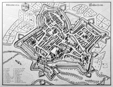
The engraver made a few errors in numbering the churches:1. Cathedral2. St. Andrew3. St. James4. St. George5. St. Paul (not holy cross)- above st. Paul, beyond brühl and brühltor, with staircase, no number: holy cross- to the right of st. Paul, beyond the crossroads, no number: capuchin church at lüchtenhof6. St. Lamberti7. St. Michael8. St. Godehard- to the left of it, no number: st. Nicholas chapel9. St. Annen (not st. Catharina; the katharinenspital with church and cemetery was in front of the ostertor [21] beyond the image border)10. St. Martin (not st. Paul, see no. 5)- to the right of it by the cathedral, no number: chapel of the magdalenenstift11. (number in the picture with correction mark from 10) st. Magdalenen (not st. Martini, see no. 10). Date: before 1653. Medium: copper engraving print. Hildesheim (Merian)
Loading...