Evert Maaskamp, Afb KAVA00065000001, Evert Maaskamp, 1809 t/m 1811

Evert Maaskamp, Afb KAVA00065000001, Evert Maaskamp, 1809 t/m 1811

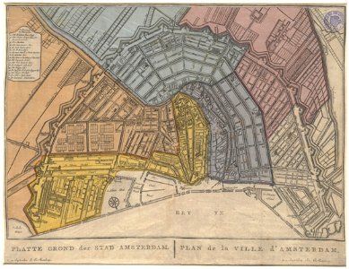
Description flat ground of the city of amsterdam. Plan de la ville d'amsterdam map of amsterdam. 5th edition. Scale approx. 1:12,000. Published by evert maaskamp. The city was divided, by coloring, into the six cantons of the justices of the peace. The accompanying text with the title: division de la ville d'amsterdam en six cantons is missing (see saa: 10035/1058). Orientation: south-southwest above. Document type: card manufacturer: maaskamp, ​​e. (evert; 1769-1834) collection: amsterdam city archives collection: maps of the whole of amsterdam dating: 1809 to 1811 inventories: http://archief. Amsterdam/archief/10035/1057 image file: kava00065000001 + - 70% leaflet. Date: 1809 t/m 1811.
Edit image
Published by:
Creazilla
Author: Maaskamp, E. (Evert; 1769-1834)Source: commons.wikimedia.org

Loading...

0 downloads
Loading...
evert maaskampold maps of amsterdam

MORE LIKE THIS

Creazilla logo
Over 10 million free graphic resources for content creators and designers.
© 2018 - 2025 Creazilla
Our resourcesAll imagesPhotosDigital illustrationsClipartIconsPNG ImagesEmojisSilhouettesTraditional Art3D ModelsVectorsFontsColor namesColor palettesGradientsAudioAnimationVideosTemplates
InformationAbout CreazillaTerms of useTech teamPrivacy policyLicence Information
FeedbackContact Us