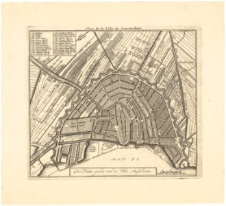
Description the map of the city of amsteldam. Plan de la ville de amsterdam
map of amsterdam. Design by daniel stopendael. 3rd edition. Scale approx. 1:24,000. Published by hendrik de leth. The map was included in the: new geographical and historical atlas of the seven united dutch provinces, published by hendrik de leth. This work first appeared in 1740. The last known edition dates from 1772. For a 2nd edition of the map see: saa, kok collection: 10095/154, for a 4th edition: 10095/155. Orientation: south-southwest above. Document type: card
manufacturer: stopendaal, daniël
leth, hendrik de
collection: amsterdam city archives collection: maps of the whole of amsterdam
dating: 1740 to 1772
inventories: http://archief. Amsterdam/archief/10035/952
image file: kava00038000001
+
-
70%
leaflet. Date: 1740 t/m 1772.
Loading...