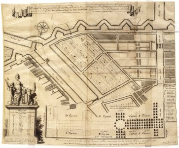
Description map showing the plan of the nieuwe plantage between the heere gragt and the muider poort; like the same one by ed. Honorable council of the city of amsterdam was arrested on 16 january ao. 1682
map with a new park layout of the plantage. Signed and published by jacob bosch. Engraved by daniël stoopendael. 1st edition. Scale approx. 1:4,400. The title refers to the decision of the city council on this matter of january 16, 1682. With a register of the length and width of the plots (called playgrounds). The map served as an example for saa: 10001/79. Orientation: south-southeast above. Document type: card
manufacturer: stopendaal, daniël
bosch, jacob (surveyor)
collection: atlas splitgerber collection
dating: 1682 ca. Geographical name: plantation
inventories: http://archief. Amsterdam/archief/10001/77
image file: 010001000609
+
-
70%
leaflet. Date: circa 1682.
Loading...