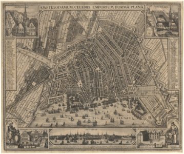
Description amstelodamum celebre emporium forma plana
map of amsterdam. 2nd edition. Scale approx. 1:7,250. Published by claes jansz visscher. For a 1st edition of this map see saa, kok collection: 10094/20. However, the four corners of that copy were cut away. Compared to the 1st edition, the planned city wall of the fourth explanation was added to the 2nd edition. The realen island was extended westwards. Orientation: south-southwest above. Document type: card
manufacturer: visscher, claes jansz (1587-1652)
collection: amsterdam city archives collection: maps of the whole of amsterdam
dating: 1643
geographical name: oude hoogstraat
men's market
building: west indian house
east indian house
inventories: http://archief. Amsterdam/archief/10035/1324
image file: kava00094000001
+
-
70%
leaflet. Date: 1643.
Loading...