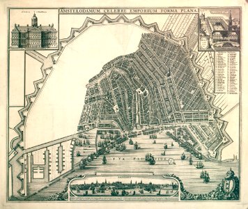
Description amstelodamum celebre emporium forma plana
map of amsterdam with a completed third explanation and the bastions of the fourth explanation. However, the area within the bastions of the fourth explanation remained empty. Scale 1:7,250. Probably made by nicolaes visscher or joan blaeu on behalf of the city council. This would allow the city council to draw variations on the interpretation itself. It is the final version of the copper plate. In 2011, the copper plate of this map was found (special collections, university of amsterdam), on which the fourth explanation appeared not to have been completed. Orientation: south-southwest above. Document type: card
manufacturer: visscher, claes jansz (1587-1652)
collection: amsterdam city archives collection: maps of the whole of amsterdam
dating: 1661 ca. Inventories: http://archief. Amsterdam/archief/10035/260
image file: 010035000054
+
-
70%
leaflet. Date: circa 1661.
Loading...