Claes Jansz Visscher, Afb 010001000818, circa 1643

Claes Jansz Visscher, Afb 010001000818, circa 1643

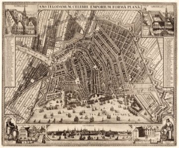
Description amstelodamum celebre emporium forma plana map of amsterdam. 2nd edition. Scale approx. 1:7,250. Published by claes jansz. Fisher. The map is decorated with images of the old town hall on dam square, the exchange of hendrik de keyser, the oostindisch huis (the former bushuis built in 1555) and the westindisch huis. Bottom center a city profile seen from the ij with text in latin and dutch. Orientation: south-southwest above. Document type: card manufacturer: visscher, claes jansz (1587-1652) collection: atlas splitgerber collection dating: 1643 ca. Inventories: http://archief. Amsterdam/archief/10001/9 image file: 010001000818 + - 70% leaflet. Date: circa 1643.
Edit image
Published by:
Creazilla
Author: Visscher, Claes Jansz (1587-1652)Source: commons.wikimedia.org

Loading...

0 downloads
Loading...
maps in the stadsarchief amsterdamclaes jansz. visscher (ii)

MORE LIKE THIS

Creazilla logo
Over 10 million free graphic resources for content creators and designers.
© 2018 - 2025 Creazilla
Our resourcesAll imagesPhotosDigital illustrationsClipartIconsPNG ImagesEmojisSilhouettesTraditional Art3D ModelsVectorsFontsColor namesColor palettesGradientsAudioAnimationVideosTemplates
InformationAbout CreazillaTerms of useTech teamPrivacy policyLicence Information
FeedbackContact Us