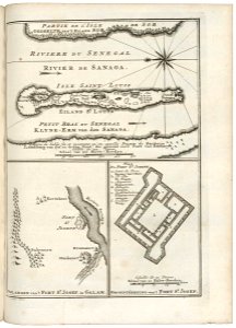
Map of the island of St. Louis in the Sanaga River and a floor plan and map of the St. Joseph fort, Jakob van der Schley, 1750
Map of the island of st. Louis in the sanaga river and a floor plan and chart of the st. Joseph fort. Omlanden van 't fort st. Josef, in galam. / grondtékening van 't fort st. Josef. Key a-f. Date: 1750. Dimensions: height: 19 cm (7.4 in); width: 26 cm (10.2 in). Medium: engraving on paper. Collection: Koninklijke Bibliotheek. AMH-8090-KB Map of the island of St. Louis in the Sanaga River and a floor plan and map of the St. Joseph fort