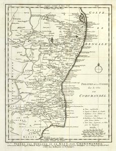
Map of the theatre of war on the Cormandel coast, Jakob van der Schley, 1756
Map of the theatre of war on the coast of cormandel. Toneel des oorlogs op de kust van choromandel. Theatre de la guerre sûr la côte de coromandel. It is not clear which war is being referred to. The symbols on the map are explicated bottom right. Date: 1756. Dimensions: height: 19 cm (7.4 in); width: 24.5 cm (9.6 in). Medium: engraving on paper. Collection: Koninklijke Bibliotheek. AMH-8023-KB Map of the theatre of war on the Cormandel coast