Map of Cape Verde with a view of the island of Goeree, Jakob van der Schley, 1747

Map of Cape Verde with a view of the island of Goeree, Jakob van der Schley, 1747

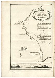
Map of cape verde with a view of the island of goeree. Naauwkeurige kaart / van de kust van / kabo verde; / met het gezigt van / k. Emanuel en 't eil. Goerée. Carte exacte / de la cóte du / cap verd; / avec la vuë du / c. Emanuel & de l'isle goerée. Par cette carte dont barbot vante / l'exactutude, il paroit que le cap verd n'est pas la pointe la plus occidentale de l'afrique. Uit deeze kaart (voor naaukeurig door barbot op gegeeven) blijkt het, dat kaap verde geenzins de westelijkste hoek van afrika is. Date: 1747. Dimensions: height: 18.5 cm (7.2 in); width: 26 cm (10.2 in). Medium: engraving on paper. Collection: Koninklijke Bibliotheek. AMH-7882-KB Map of Cape Verde with a view of the island of Goeree
Edit image
Published by:
Creazilla
Author: Jakob van der SchleySource: commons.wikimedia.org

Loading...

0 downloads
Loading...
maps of the west-indische compagnie1747 maps of africa18th-century maps of cape verdemaps by jakob van der schleyengraving on paperkoninklijke bibliotheekjakob van der schley

MORE LIKE THIS

Creazilla logo
Over 10 million free graphic resources for content creators and designers.
© 2018 - 2025 Creazilla
Our resourcesAll imagesPhotosDigital illustrationsClipartIconsPNG ImagesEmojisSilhouettesTraditional Art3D ModelsVectorsFontsColor namesColor palettesGradientsAudioAnimationVideosTemplates
InformationAbout CreazillaTerms of useTech teamPrivacy policyLicence Information
FeedbackContact Us