Map of the world, Jakob van der Schley, 1750

Map of the world, Jakob van der Schley, 1750

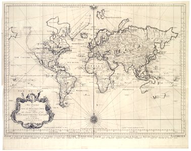
Map of the world. Proef van eene aan-eengeschakelde kaart der bekende-deelen des gantschen aardbols. An essay of a new and compact map, containing the known parts of the terrestrial globe / by n. Bellin / engineer of the marine / at the hague bu p. De hondt / mdccl. Essay d'une carte reduite contenant les parties connues du globe terrestre / par n. Bellin ingenieur ordinaire de la marine. A la haye chez pierre de hondt mdccl. Date: 1750. Dimensions: height: 72 cm (28.3 in); width: 57 cm (22.4 in). Medium: engraving on paper. Collection: Koninklijke Bibliotheek. AMH-7876-KB Map of the world
Edit image
Published by:
Creazilla
Author: Jakob van der SchleySource: commons.wikimedia.org

Loading...

0 downloads
Loading...
old maps of the dutch east india company1750 mapsmdccl (numeral)1750s maps of the worldmaps by jakob van der schleyengraving on paperkoninklijke bibliotheekjakob van der schley

MORE LIKE THIS

Creazilla logo
Over 10 million free graphic resources for content creators and designers.
© 2018 - 2025 Creazilla
Our resourcesAll imagesPhotosDigital illustrationsClipartIconsPNG ImagesEmojisSilhouettesTraditional Art3D ModelsVectorsFontsColor namesColor palettesGradientsAudioAnimationVideosTemplates
InformationAbout CreazillaTerms of useTech teamPrivacy policyLicence Information
FeedbackContact Us