Map of Anjuan, Jakob van der Schley, 1747

Map of Anjuan, Jakob van der Schley, 1747

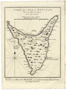
Map of anjuan. Kaart van 't eiland anjuan, een der komorose eilanden / door kapt. Cornwall. Cart de l'isle d'anjouan / une des isles de comore: par le cap:e cornwal. Cf. Koninklijke bibliotheek, the hague, inv. Nr. 3032 b 12, after p. 392. Date: 1747. Dimensions: height: 16 cm (6.2 in); width: 20 cm (7.8 in). Medium: engraving on paper. Collection: Koninklijke Bibliotheek. AMH-7963-KB Map of Anjuan
Edit image
Published by:
Creazilla
Author: Pieter de HondtSource: commons.wikimedia.org

Loading...

0 downloads
Loading...
old maps of anjouan1747 mapsmaps by jakob van der schleyengraving on paperkoninklijke bibliotheekjakob van der schley

MORE LIKE THIS

Creazilla logo
Over 10 million free graphic resources for content creators and designers.
© 2018 - 2025 Creazilla
Our resourcesAll imagesPhotosDigital illustrationsClipartIconsPNG ImagesEmojisSilhouettesTraditional Art3D ModelsVectorsFontsColor namesColor palettesGradientsAudioAnimationVideosTemplates
InformationAbout CreazillaTerms of useTech teamPrivacy policyLicence Information
FeedbackContact Us