Map of China and Korea, Jakob van der Schley, 1749

Map of China and Korea, Jakob van der Schley, 1749

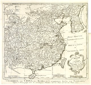
Map of china and korea. 't keizerryk van china, met koréa, en de aangrenzende deelen van tartarye, / volgens de kaart geligt door de zendelingen, jezuïten, van de jaare 1708 tot den jaare 1717. La chine avec la korée et les parties de la tartarie les plus voisines, tirée des cartes que les jesuites misionaires ont levées kes annees 1708 jusqu'en 1717. Date: 1749. Dimensions: height: 31 cm (12.2 in); width: 27.5 cm (10.8 in). Medium: engraving on paper. Collection: Koninklijke Bibliotheek. AMH-7966-KB Map of China and Korea
Edit image
Published by:
Creazilla
Author: Jakob van der SchleySource: commons.wikimedia.org

Loading...

0 downloads
Loading...
maps of the dutch east india company - koreamaps of the dutch east india company - china1749 maps of asiamaps by jakob van der schley1740s maps of china18th-century maps of koreafrench-language maps of asiadutch-language mapsmaps using ferro prime meridianmaps using beijing prime meridianjacobus van der schleywillow palisademaps of the great wall of chinaengraving on paperkoninklijke bibliotheekjakob van der schley

MORE LIKE THIS

Creazilla logo
Over 10 million free graphic resources for content creators and designers.
© 2018 - 2025 Creazilla
Our resourcesAll imagesPhotosDigital illustrationsClipartIconsPNG ImagesEmojisSilhouettesTraditional Art3D ModelsVectorsFontsColor namesColor palettesGradientsAudioAnimationVideosTemplates
InformationAbout CreazillaTerms of useTech teamPrivacy policyLicence Information
FeedbackContact Us