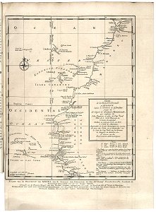
Map of the west coast of Africa, from Gibraltar to 9 degrees north latitude, Jakob van der Schley, 1747
Map of the west coast of africa, from gibraltar to 9 degrees north latitude. Kaart van de westkust van afrika, van de straat van gibraltar tot den xie graad noorderbreedte: bevattende de / kanarise-eilanden met die van kabo verde. Carte de la coste occidentale d'afrique, depuis le d??troit de gibraltar jusqu'au xie degré de latitude septentrionale, qui renferme les isles canaries et celle dus cap verde. Key: nota / b. Baye. Baai. / c. Cap. Kaap. / g. Golphe. Golf. / i. Isle. Eiland. / p. Port. Haven. Pt. Point. Hoek. Date: 1747. Dimensions: height: 32 cm (12.5 in); width: 23.5 cm (9.2 in). Medium: engraving on paper. Collection: Koninklijke Bibliotheek. AMH-7877-KB Map of the west coast of Africa, from Gibraltar to 9 degrees north latitude