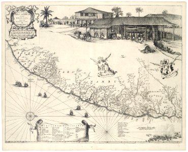
Map of pernambuco and tamarica. Pernambuca / i. Tamarica. The key in the scroll is explained by means of symbols. Key bottom right: a. Ilha dos cedros, ou d'ant:o vaaz. / b. Citade maurtia, v. Maurits stadt. C. F. Frederick henrick, v: vyfhoeck. / d. F. Ernestus, daer by vryburg ligt. / e. F. Waerdenberg, v. Dryhoeck. / f. Stede reciff. / g. Watercasteel, v. Castello do mar. / h. Castello de s. Iorge, v. Landtcasteel. K. Fort de bruyn. / l. F. Ioffrou de bruyn. / m. F. Prins willem aen r. Dos affogados. / n. Rio dos afogados. / o. Teiibipio, eene rivier. / p. Capiibari, een rivier. / q. Iabebiri, een rivier. Legenda links: 1. Guaibitingamiri. / 2. Fonte de s. Thomé. / 3. R. Tapado. / 4. R. De graspar gonçalo. I. Xii. Ianuarij an. Mdcxl. Conflixit primo cum hollandorum claße, hispanica, hac altitudine ex adverso i. Tamarica. The map was reproduced in joan blaeu's 'atlas maior' (1665). The map features the coats of arms of pernambuco and itamaracá. Almost the entire top part of the chart is occupied by a drawing of a sugar refinery, with in the background houses of european colonists. Bottom right a depiction of the first day of the sea battle between the dutch and spanish fleets on january 12 1640. The rest of the sea battle and the remaining part of the sugar mill are shown on the next chart: koninklijke bibliotheek, the hague, inv. Nr. 1043 b 14, after p. 68. This map can be linked with: koninklijke bibliotheek, the hague, inv. Nr. 1043 b 14, after p. 28; idem, inv. Nr. 1043 b 14, after p. 38, 2, and idem, inv. Nr. 1043 b 14, after p. 68. Cf. Koninklijke bibliotheek, the hague, inv. Nr. 1049b13_095. Object Type: copper engraving print, map. Genre: figurative art. Date: 1647. Dimensions: height: 56 cm (22 in); width: 46 cm (18.1 in). Medium: copperplate printing on paper. Collection: Koninklijke Bibliotheek. AMH-7288-KB Map of Pernambuco and Tamarica
Loading...