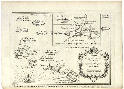
Map of a part of the West African coast with an inset showing the mouth of the Sestos, Jakob van der Schley, 1747
Map of a part of the west african coast with an inset showing the mouth of the sestos. Gedeelte van de kust van guin??e, van kaap monte tot kaap baixos. Uit barbot. Partie de la coste de guin??e / depuis le cap de monte jusqu'au cap des basses / tir??e de barbot. Carte de la riviere de sestre / kaart van de riv. Sestos. This map is continued before page 1 from the same book. Date: 1747. Dimensions: height: 18.5 cm (7.2 in); width: 13 cm (5.1 in). Medium: engraving on paper. Collection: Koninklijke Bibliotheek. AMH-7944-KB Map of a part of the West African coast with an inset showing the mouth of the Sestos