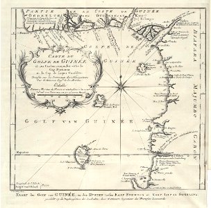
Map of part of the West African coast, between Cape Formosa and Cape Lopez Gonsalvo, Jakob van der Schley, 1747
Map of part of the west african coast, between cape formosa and cape lopez gonsalvo. Kaart der golf van guinée, en der kusten tussen kaap formosa en kaap lopez gonsalvo. Carte du golfe de guinée et les costes comprises entre le cap formosa et le cap de lopes consalvo. Dressée sur les journaux des navigateurs par n. Bellin ing:r de la marine. Date: 1747. Dimensions: height: 21 cm (8.2 in); width: 20.5 cm (8 in). Medium: engraving on paper. Collection: Koninklijke Bibliotheek. AMH-7953-KB Map of part of the West African coast, between Cape Formosa and Cape Lopez Gonsalvo