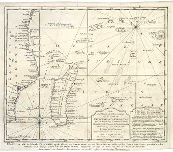
Map of part of the African east coast and Madagascar, Jakob van der Schley, 1747
Map of part of the east coast of africa and madagascar. Kaart van alle de bekende eilanden op de kust van zanguebar en van madagascar, welke op den vaard naar indie gevonden worden
bottom right an explication of the abbreviations used. Carte de toutes les isles connues sur la coste de zanguebar et de madagascar que l'on trouve dans la route de l'inde. Date: 1747. Dimensions: height: 21 cm (8.2 in); width: 18.5 cm (7.2 in). Medium: engraving on paper. Collection: Koninklijke Bibliotheek. AMH-7923-KB Map of part of the African east coast and Madagascar