Map of a part of Africa, Willem Blaeu, 1635

Map of a part of Africa, Willem Blaeu, 1635

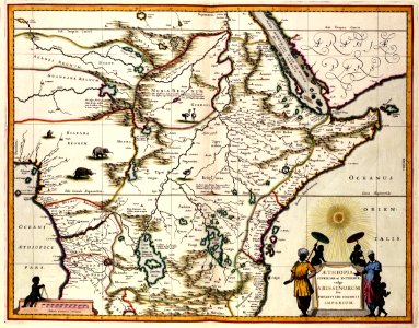
Map of a part of africa. Aethiopia superior vel interior; vulgo abissinorum sive presbiteri ioannis imperium:. This map of ethiopia was published in 1635 by willem jansz. Blaeu (1571-1638). It is not known which geographical source blaeu used to compile the chart. The latin title of the map makes reference to pape jan, a catholic priest said to have founded a christian state in africa. Cf. Koninklijke bibliotheek, the hague, inv. Nr. 185 b 11 part 1, after p. 666. Date: 1635. Dimensions: height: 54 cm (21.2 in); width: 42 cm (16.5 in). Medium: coloured engraving on paper. Collection: Koninklijke Bibliotheek. AMH-7762-KB Map of a part of Africa
Edit image
Published by:
Creazilla
Author: Willem BlaeuSource: commons.wikimedia.org

Loading...

0 downloads
Loading...
old maps of the dutch east india company - africa1635 maps of africa1630s maps of ethiopiamaps by willem and johannes blaeucoloured engraving on paperkoninklijke bibliotheekwillem blaeu

MORE LIKE THIS

Creazilla logo
Over 10 million free graphic resources for content creators and designers.
© 2018 - 2025 Creazilla
Our resourcesAll imagesPhotosDigital illustrationsClipartIconsPNG ImagesEmojisSilhouettesTraditional Art3D ModelsVectorsFontsColor namesColor palettesGradientsAudioAnimationVideosTemplates
InformationAbout CreazillaTerms of useTech teamPrivacy policyLicence Information
FeedbackContact Us