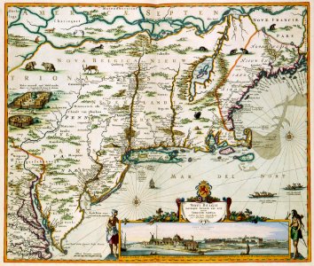
Map of nieuw nederland. Novi belgii novae que angliae nec non partis virginae tabula multis in locis emendata / nieuw amsterdam op t eylant manhattans. This map of what is now known as new england was published by nicolaas visscher ii (1649-1702). For this edition visscher first copied a chart from 1651 by johannes janssonius and subsequently added a view of new amsterdam (today's manhattan). The map is highly detailed: almost every european settlement which existed at that time has been depicted. Key: a-k. For the view of manhattan: cf. National archives, the hague, inv. Nr. Velho619. 14 and rijksmuseum amsterdam, inv. Nr. Ng-28 and ibid, inv. Nr. Ng-20-d. For the map: cf. Koninklijke bibliotheek, the hague, inv. Nr. 185 b 14 part ii, after p. 122. For both the map and the inset: national archives, the hague, inv. Nr. Velh0568d. Date: 1684. Dimensions: height: 58 cm (22.8 in); width: 48 cm (18.8 in). Medium: coloured engraving on paper. Collection: Koninklijke Bibliotheek.
Loading...