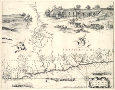
Map of paraíba and rio grande. Praefecturae de paraiba, et rio grande. The chart was later reproduced in joan blaeu's atlas maior. The map displays the coats of arms of the governorships paraíba and rio grande. Topping the map is an illustration of a village with a church, and brazilian indians working for the dutch. In the top left corner we see part of the drawing of the sugar mill, of which the greater part features on the map of pernambuco and itamarica, koninklijke bibliotheek, the hague, inv. Nr. 1043 b 14, after p. 38. The sea battle shown here, depicts the continuation of the battle fought in january 1640 between the dutch and the spaniards. It concerns the dates of 13, 14 and 17 january. The first day of this sea battle is depicted on the same chart as that showing the rest of the sugar mill. This map may be linked to: koninklijke bibliotheek, the hague, inv. Nr. 1043 b 14, after p. 28; idem, inv. Nr. 1043 b 14, after p. 38, 2, and idem, inv. Nr. 1043 b 14, after p. 68. Cf. Koninklijke bibliotheek, the hague, inv. Nr. 1049b13_097. Date: 1647. Dimensions: height: 53 cm (20.8 in); width: 41 cm (16.1 in). Medium: copperplate printing on paper. Collection: Koninklijke Bibliotheek.
Loading...