Map of Recife and Mauritsstad, Jacob van Meurs, circa 1682

Map of Recife and Mauritsstad, Jacob van Meurs, circa 1682

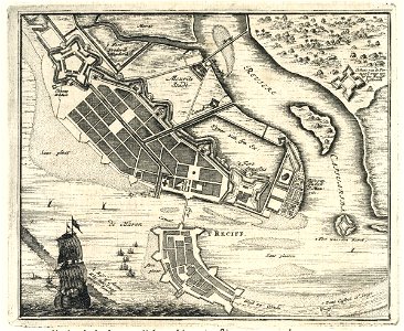
Map of recife and mauritsstad. Various notes have been added to the map. The map closely resembles that by johannes vingboons, national archives, inv. Nr. Velj 619. 74. Cf. Rijksmuseum, amsterdam, inv. Nr. Ng-20-d. Date: circa 1682. Dimensions: height: 17 cm (6.6 in); width: 14 cm (5.5 in). Medium: engraving on paper. Collection: Koninklijke Bibliotheek. AMH-6921-KB Map of Recife and Mauritsstad
Edit image
Published by:
Creazilla
Author: Anna GoeletSource: commons.wikimedia.org

Loading...

0 downloads
Loading...
maps of the west-indische compagnie1682maps by jacob van meursweduwe van jacob van meursrecifeengraving on paperkoninklijke bibliotheekjacob van meurs

MORE LIKE THIS

Creazilla logo
Over 10 million free graphic resources for content creators and designers.
© 2018 - 2025 Creazilla
Our resourcesAll imagesPhotosDigital illustrationsClipartIconsPNG ImagesEmojisSilhouettesTraditional Art3D ModelsVectorsFontsColor namesColor palettesGradientsAudioAnimationVideosTemplates
InformationAbout CreazillaTerms of useTech teamPrivacy policyLicence Information
FeedbackContact Us