Map of Guiana, Jacob van Meurs, circa 1671

Map of Guiana, Jacob van Meurs, circa 1671

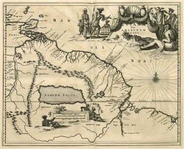
Map of guiana. Gviana siue amazonvm. The lake primum lacus doesn't exist, but is shown on many maps dating from this period. A waterfall is located on a tributary of the amazon: vallen, storting van het water. This map closely resembles that of koninklijke bibliotheek, inv. Nr. 36 g 19 na p. 552. Date: circa 1671. Dimensions: height: 36.5 cm (14.3 in); width: 29.5 cm (11.6 in). Medium: engraving on paper. Collection: Koninklijke Bibliotheek. AMH-6828-KB Map of Guiana
Edit image
Published by:
Creazilla
Author: Jacob van MeursSource: commons.wikimedia.org

Loading...

1 download
Loading...
maps of the west-indische compagnie1671maps by jacob van meursengraving on paperkoninklijke bibliotheekjacob van meurs

MORE LIKE THIS

Creazilla logo
Over 10 million free graphic resources for content creators and designers.
© 2018 - 2025 Creazilla
Our resourcesAll imagesPhotosDigital illustrationsClipartIconsPNG ImagesEmojisSilhouettesTraditional Art3D ModelsVectorsFontsColor namesColor palettesGradientsAudioAnimationVideosTemplates
InformationAbout CreazillaTerms of useTech teamPrivacy policyLicence Information
FeedbackContact Us