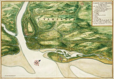
Title in the leupe catalogue (na): "caerte van 't eijland tamaraca neffens het steedeken schop ende 't fort orangiën". Map of the island of tamaraca. Caerte van 't eylandt tamaraca neffens het steedeken schop ende 't fort orangien met haer geleegenhede van dien. Key: a. Is de berg daer 't steedeken op leght, genaemt n. S. O. Concicao, ofte stadt schop / b. Het casteel op den bergh / c. De cappel / d. 't gasthuijs / e. Retrenschemente om de stadt / f. Redout / g. Packhuijs / h. Stadt huijs / i. De engeiho haerlem ofte suijcker moolen haer: / k. Inwoonders huijsen op 't vaste landt / 1: 't woon huijs, 2: de molen haerlem, 3: 't purgeer huijs 4 pottebackerij / 5: negers huijsen 6: een watterbeeckie. Remarks: the chart is contained in the vingboons atlas. Cf. Koninklijke bibliotheek, den haag, inv. Nr. 1043 b 14, after p. 52 no. 19. Date: circa 1665. Dimensions: height: 63 cm (24.8 in); width: 43 cm (16.9 in). Medium: watercolour on paper. Collection: Nationaal Archief. AMH-6799-NA Map of the island of Tamaraca
Loading...