Map of the mouth of the Paraiba River, Johannes Vingboons, circa 1665

Map of the mouth of the Paraiba River, Johannes Vingboons, circa 1665

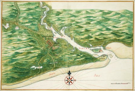
Title in the leupe catalogue (na): kaart van de monding der rio de paraiba. Met loodingen. Map of the mouth of the paraiba river. Remarks: the map is contained in the vingboons atlas. Cf. Koninklijke bibliotheek, 1043 b 14, na p. 70, no 26. Cf. Koninklijke bibliotheek, den haag, inv. Nr. 40 e 7 after p. 416 and idem, 1043 b 14, after p. 70 no. 26. Date: circa 1665. Dimensions: height: 63 cm (24.8 in); width: 42 cm (16.5 in). Medium: watercolour on paper. Collection: Nationaal Archief. AMH-6786-NA Map of the mouth of the Paraiba River
Edit image
Published by:
Creazilla
Author: Johannes VingboonsSource: commons.wikimedia.org

Loading...

0 downloads
Loading...
maps of the west-indische compagnieold maps of dutch brazil1665atlas vingboonswatercolour on papernationaal archiefjohannes vingboons

MORE LIKE THIS

Creazilla logo
Over 10 million free graphic resources for content creators and designers.
© 2018 - 2025 Creazilla
Our resourcesAll imagesPhotosDigital illustrationsClipartIconsPNG ImagesEmojisSilhouettesTraditional Art3D ModelsVectorsFontsColor namesColor palettesGradientsAudioAnimationVideosTemplates
InformationAbout CreazillaTerms of useTech teamPrivacy policyLicence Information
FeedbackContact Us