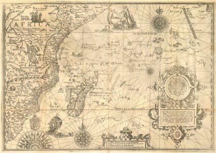
Map of the east african coast. Affbeeldinghe der custen des landts genaempt terra do natal, item van alle de custen van coffala, mozambique, melinde, ende t'eylandt van s. Lorenzo: met alle haere eylanden, clippen, droochten, ende ondiepten. Item d'eylanden van maldiva tot het eylandt ceylon, ende den hoeck van comori toe, aende custen van indien liggende, met de waerachtighe streckinghe ende gheleghentheyt der zlver, alles seer correctelijck naer d'allerbeste indiaensche pas ende lees-caerten, oversien ende verbeetert. Delineatio orarum maritimarum, terrae vulgo indigetatae terra do natal, item sofala, mozambicae, & melindae, insulaeq: sancti laurentij, insularum maldiuicaroum, seylon insulae, & promontorij comorini, ad indiam siti unà cum insulis, scopulis, pulvinis, vadis, veris ventorum tractibus, & geuino singulorum locorum sicu, ad exactissimas ichonographicas indicarum tabulas recognita atq: emendata. Various creatures are depicted, both on land and in the water. Date: circa 1623. Dimensions: height: 40.5 cm (15.9 in); width: 57 cm (22.4 in). Medium: engraving on paper. Collection: Koninklijke Bibliotheek.
Loading...