Map of Pernambuco, Johannes Vingboons, circa 1665

Map of Pernambuco, Johannes Vingboons, circa 1665

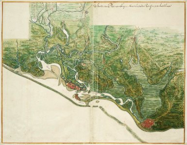
Title in the leupe catalogue (na): kaart van de "haven van pharnambucq, maritiusstad, recif en de stad olinda". Map of pernambuco. De haven van pharnambucq. Key: (1) maritius stad (2) recif en (3) de stad olinda. Top left a box has been created that has not been filled in. Remarks: the map is contained in the vingboons atlas. Date: circa 1665. Dimensions: height: 59 cm (23.2 in); width: 46 cm (18.1 in). Medium: watercolour on paper. Collection: Nationaal Archief. AMH-6784-NA Map of Pernambuco
Edit image
Published by:
Creazilla
Author: Johannes VingboonsSource: commons.wikimedia.org

Loading...

0 downloads
Loading...
1665 maps of brazil1660s maps of pernambucomaps of the west-indische compagnieold maps of dutch brazil1665 in pernambucoatlas vingboonswatercolor drawings by johannes vingboonswatercolour on papernationaal archiefjohannes vingboons

MORE LIKE THIS

Creazilla logo
Over 10 million free graphic resources for content creators and designers.
© 2018 - 2025 Creazilla
Our resourcesAll imagesPhotosDigital illustrationsClipartIconsPNG ImagesEmojisSilhouettesTraditional Art3D ModelsVectorsFontsColor namesColor palettesGradientsAudioAnimationVideosTemplates
InformationAbout CreazillaTerms of useTech teamPrivacy policyLicence Information
FeedbackContact Us