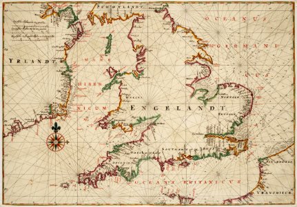
Map of England, the south of Ireland and part of the French coast, Johannes Vingboons, circa 1665
Title in the leupe catalogue (na): kaart van het zuideljk gedeelte der noordzee, het kanaal en de iersche zee met een gedeelte van de noordkust van frankrijk. Met loodingen. Map of england, the south of ireland and part of the french coast. Remark in the leupe catalogue concerning the scale: wassende. Remarks: the chart forms part of the vingboons atlas. Date: circa 1665. Dimensions: height: 69 cm (27.1 in); width: 48 cm (18.8 in). Medium: watercolour on paper. Collection: Nationaal Archief. AMH-6813-NA Map of England, the south of Ireland and part of the French coast