Map of Table Bay, Johannes Vingboons, circa 1665

Map of Table Bay, Johannes Vingboons, circa 1665

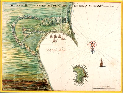
Title in the leupe catalogue (na): kaart van de tafelbaai. Met loodingen. The illustration shows a view of table bay and the immediate surroundings tafel baij, leeuwen bergh, robben eijland, tafel bergh. Top is the inscription de tafel bay geleegen aende cabo de bona speranca. Op 34 graden. Bottom right the scale twee duijtsche mijlen. Cf. Österreichische nationalbibliothek, vienna, inv. Nr. Van der hem 38:04 and british library, london, inv. Nr. Add. 34. 184-6. Date: circa 1665. Dimensions: height: 60 cm (23.6 in); width: 45 cm (17.7 in). Medium: watercolour on paper. Collection: Nationaal Archief. AMH-6143-NA Map of Table Bay
Edit image
Published by:
Creazilla
Author: Johannes VingboonsSource: commons.wikimedia.org

Loading...

0 downloads
Loading...
maps of the dutch east india company - south africa1665watercolor drawings by johannes vingboonswatercolour on papernationaal archiefjohannes vingboons

MORE LIKE THIS

Creazilla logo
Over 10 million free graphic resources for content creators and designers.
© 2018 - 2025 Creazilla
Our resourcesAll imagesPhotosDigital illustrationsClipartIconsPNG ImagesEmojisSilhouettesTraditional Art3D ModelsVectorsFontsColor namesColor palettesGradientsAudioAnimationVideosTemplates
InformationAbout CreazillaTerms of useTech teamPrivacy policyLicence Information
FeedbackContact Us