Map of the city of Macao, Johannes Vingboons, circa 1665

Map of the city of Macao, Johannes Vingboons, circa 1665

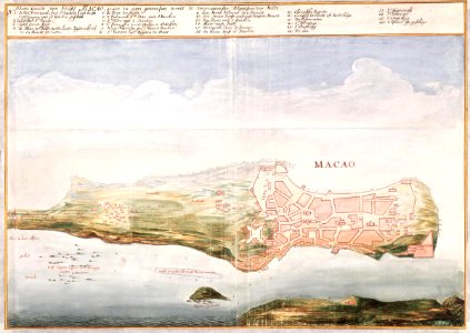
Title in the leupe catalogue (na): plattegrondt van [de] stadt macao. It corresponds entirely with that which is rendered in valentijn iv, 2nd part, page 2. Key on the chart 1-26 platte grondt van stadt macao, waer in aen geweesen wordt de voornaemste plaetsen der stadt. The following labels are given on the chart: deese clippen leggen met springtij onder waater, papen eylandt. Deese drooghte lyt meest booven waeter, rys landt, paden,vlack veldt, macao. Date: circa 1665. Dimensions: height: 59 cm (23.2 in); width: 41.5 cm (16.3 in). Medium: watercolour on paper. Collection: Nationaal Archief. AMH-6155-NA Map of the city of Macao
Edit image
Published by:
Creazilla
Author: Johannes VingboonsSource: commons.wikimedia.org

Loading...

0 downloads
Loading...
1665watercolor drawings by johannes vingboonswatercolour on papernationaal archiefjohannes vingboons

MORE LIKE THIS

Creazilla logo
Over 10 million free graphic resources for content creators and designers.
© 2018 - 2025 Creazilla
Our resourcesAll imagesPhotosDigital illustrationsClipartIconsPNG ImagesEmojisSilhouettesTraditional Art3D ModelsVectorsFontsColor namesColor palettesGradientsAudioAnimationVideosTemplates
InformationAbout CreazillaTerms of useTech teamPrivacy policyLicence Information
FeedbackContact Us