Map of the fort at Trinconomale, Carel Frederik Reimer, 10 November 1787

Map of the fort at Trinconomale, Carel Frederik Reimer, 10 November 1787

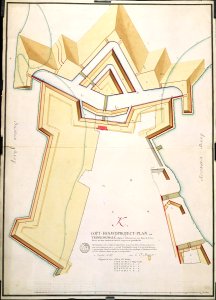
According to the leupe catalogue (na), the original title reads: hoofdproject plan van trinkonomalé, volgens 't ontwerp van den heer de la lustière, tot beter onderzoek daarvan, vergroot en gedetailleerd. The new fortifications are indicated in yellow and red, while the existing ones are shown in black. Notes on reverse: [blue label odg] nr. :36a projet-plan van trinconomale. Etiket nr. 555. Date: 10 November 1787. Dimensions: height: 73 cm (28.7 in); width: 53 cm (20.8 in). Medium: coloured engraving on paper. Collection: Nationaal Archief. AMH-4505-NA Map of the fort at Trinconomale
Edit image
Published by:
Creazilla
Author: Carel Frederik ReimerSource: commons.wikimedia.org

Loading...

0 downloads
Loading...
maps of the dutch east india company - sri lankamaps of fort fredrickcarel frederik reimercoloured engraving on papernationaal archief

MORE LIKE THIS

Creazilla logo
Over 10 million free graphic resources for content creators and designers.
© 2018 - 2025 Creazilla
Our resourcesAll imagesPhotosDigital illustrationsClipartIconsPNG ImagesEmojisSilhouettesTraditional Art3D ModelsVectorsFontsColor namesColor palettesGradientsAudioAnimationVideosTemplates
InformationAbout CreazillaTerms of useTech teamPrivacy policyLicence Information
FeedbackContact Us