Map depicting the journey by Joan Nieuhoff from Canton to Peking, Jacob van Meurs, 1665

Map depicting the journey by Joan Nieuhoff from Canton to Peking, Jacob van Meurs, 1665

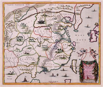
Map of the journey of joan nieuhoff from canton to peking, taken from the atlas van der hagen, koninklijke bibliotheek, the hague, part 4. A trade delegation from the dutch east india company visited peking between 1655 and 1658, with the aim of establishing trade relations with china. Among the delegation was the amsterdam-based globetrotter, johan nieuhoff. On his return he published his experiences in the form of a richly illustrated travel journal. This map, depicting the route taken by the trade delegation on its travels through china, was also included in the journal. Date: 1665. Dimensions: height: 52 cm (20.4 in); width: 44 cm (17.3 in). Medium: copperplate printing on paper. Collection: Koninklijke Bibliotheek. AMH-5649-KB Map depicting the journey by Joan Nieuhoff from Canton to Peking
Edit image
Published by:
Creazilla
Author: Jacob van MeursSource: commons.wikimedia.org

Loading...

0 downloads
Loading...
maps of the dutch east india company - china1665old maps of chinachina in the 1660sold maps of guangdongold maps of jiangxiold maps of jiangsuold maps of shandongold maps of hebeiold maps of koreaold maps of hainanold maps of taiwanmaps by jacob van meurscopperplate printing on paperkoninklijke bibliotheekjacob van meurs

MORE LIKE THIS

Creazilla logo
Over 10 million free graphic resources for content creators and designers.
© 2018 - 2025 Creazilla
Our resourcesAll imagesPhotosDigital illustrationsClipartIconsPNG ImagesEmojisSilhouettesTraditional Art3D ModelsVectorsFontsColor namesColor palettesGradientsAudioAnimationVideosTemplates
InformationAbout CreazillaTerms of useTech teamPrivacy policyLicence Information
FeedbackContact Us