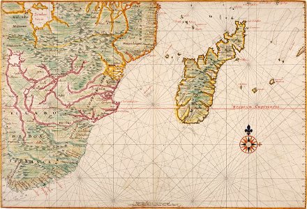
Map of southern Africa and Madagascar, Johannes Vingboons, circa 1665
Title in the leupe catalogue (na): kaart van afrika van kaap de goede hoop tot kaap delgado en het geheele eiland madagaskar. Met loodingen. Particulars: the map forms part of the vingboons atlas. The map's measurements do not include a strip of japanese paper pasted on later. On madagascar a hollanders kerckhof ['dutch graveyard'] is marked. Date: circa 1665. Dimensions: height: 69 cm (27.1 in); width: 47 cm (18.5 in). Medium: coloured drawing on paper. Collection: Nationaal Archief. AMH-5622-NA Map of southern Africa and Madagascar