Map of the city of Malakka, Johannes Vingboons, circa 1665

Map of the city of Malakka, Johannes Vingboons, circa 1665

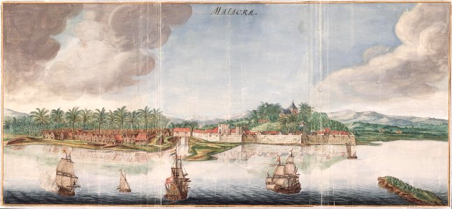
Title in the leupe catalogue (na): gezicht op de stad malakka van de zeezijde. This corresponds entirely with the illustration rendered in valentijn v, page 308. View of the city with ships in the foreground, and in the background, mountains. On the right the voc fort is depicted. Cf. Österreichische nationalbibliothek, vienna, inv. Nr. 39:15. Date: circa 1665. Dimensions: height: 96 cm (37.7 in); width: 44 cm (17.3 in). Medium: watercolour on paper. Collection: Nationaal Archief. AMH-6156-NA Map of the city of Malakka
Edit image
Published by:
Creazilla
Author: Johannes VingboonsSource: commons.wikimedia.org

Loading...

3 downloads
Loading...
media from atlas of mutual heritage on dutch east india company1665sailing ships of the netherlandsmaps by johannes vingboonsmalacca citydutch malaccaskirmish at the strait of malaccawatercolour on papernationaal archiefjohannes vingboons

MORE LIKE THIS

Creazilla logo
Over 10 million free graphic resources for content creators and designers.
© 2018 - 2025 Creazilla
Our resourcesAll imagesPhotosDigital illustrationsClipartIconsPNG ImagesEmojisSilhouettesTraditional Art3D ModelsVectorsFontsColor namesColor palettesGradientsAudioAnimationVideosTemplates
InformationAbout CreazillaTerms of useTech teamPrivacy policyLicence Information
FeedbackContact Us