Elevations of the fort at Trinconomale, Carel Frederik Reimer, 1 December 1787

Elevations of the fort at Trinconomale, Carel Frederik Reimer, 1 December 1787

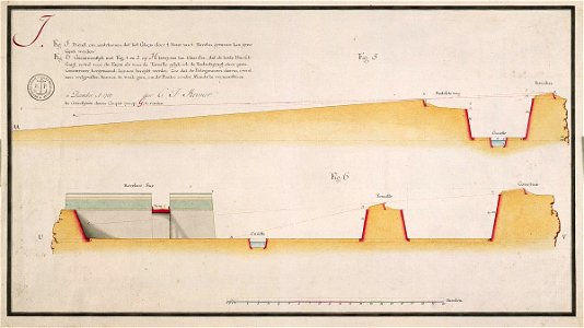
According to the leupe catalogue (na), the original title reads: plan en profils, behoorende tot de bemerkingen over 't project der h. H. Ingenieurs fornbauer, löwe en de la goupilliëre, om triconomalé vooreerst tegens een coup de main te verzekeren enz. Notes in the leupe catalogue: betreft plan j fig. 5 en 6. Notes on reverse: [blue label odg] nr: 36 c. Profilen van trinconomale. Date: 1 December 1787. Dimensions: height: 53 mm (2.08 in); width: 30 mm (1.18 in). Medium: coloured drawing on paper. Collection: Nationaal Archief. AMH-4509-NA Elevations of the fort at Trinconomale
Edit image
Published by:
Creazilla
Author: Carel Frederik ReimerSource: commons.wikimedia.org

Loading...

0 downloads
Loading...
media from atlas of mutual heritage on dutch east india companycarel frederik reimercoloured drawing on papernationaal archief

MORE LIKE THIS

Creazilla logo
Over 10 million free graphic resources for content creators and designers.
© 2018 - 2025 Creazilla
Our resourcesAll imagesPhotosDigital illustrationsClipartIconsPNG ImagesEmojisSilhouettesTraditional Art3D ModelsVectorsFontsColor namesColor palettesGradientsAudioAnimationVideosTemplates
InformationAbout CreazillaTerms of useTech teamPrivacy policyLicence Information
FeedbackContact Us