Chart of the inner bay at Trinconomale, Carel Frederik Reimer, 1787

Chart of the inner bay at Trinconomale, Carel Frederik Reimer, 1787

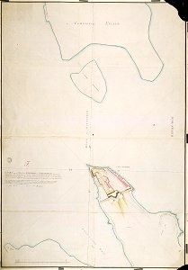
According to the leupe catalogue (na), the original title reads: kaart van de mond der binnenbay van trinconomale enz. Notes on reverse: blauw etiket [depot-generaal v. Oorlog] no. 25 "kaart van de mond van de binnen baaij van trinconomale" register 4; deel 1; folio 14 / ingang van trinconomale, tot [explanation] van 't plan van de heer la lustriere behoorende. Date: 1787. Dimensions: height: 905 mm (35.62 in); width: 1,290 mm (50.78 in). Medium: coloured drawing on paper. Collection: Nationaal Archief. AMH-2517-NA Chart of the inner bay at Trinconomale
Edit image
Published by:
Creazilla
Author: Carel Frederik ReimerSource: commons.wikimedia.org

Loading...

0 downloads
Loading...
maps of the dutch east india company - sri lanka1787 mapstrincomalee baycarel frederik reimercoloured drawing on papernationaal archief

MORE LIKE THIS

Creazilla logo
Over 10 million free graphic resources for content creators and designers.
© 2018 - 2025 Creazilla
Our resourcesAll imagesPhotosDigital illustrationsClipartIconsPNG ImagesEmojisSilhouettesTraditional Art3D ModelsVectorsFontsColor namesColor palettesGradientsAudioAnimationVideosTemplates
InformationAbout CreazillaTerms of useTech teamPrivacy policyLicence Information
FeedbackContact Us