Map of Fort Oostenburg at Trinconomale, Carel Frederik Reimer, 1 September 1785

Map of Fort Oostenburg at Trinconomale, Carel Frederik Reimer, 1 September 1785

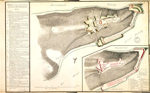
According to the leupe catalogue (na), the original title reads: plan van het fort oostenburg, zoo als hetzelve sig nog bevond in sept. 1785. Key: a-s; a-z; aa-ss note in the leupe catalogue: literatuur: w. A. Nelson, the dutch forts of sri lanka, edinburgh, 1984. Notes on reverse: [blue label odg] nr: 23 a plan van oostenburg; [printed label] nr: 567 [in the margin] plan nr. 6. 0. Date: 1 September 1785. Dimensions: height: 62 cm (24.4 in); width: 37 cm (14.5 in). Medium: coloured drawing on paper. Collection: Nationaal Archief. AMH-4524-NA Map of Fort Oostenburg at Trinconomale
Edit image
Published by:
Creazilla
Author: Carel Frederik ReimerSource: commons.wikimedia.org

Loading...

0 downloads
Loading...
maps of the dutch east india company - sri lankamaps of fort fredrickcarel frederik reimercoloured drawing on papernationaal archief

MORE LIKE THIS

Creazilla logo
Over 10 million free graphic resources for content creators and designers.
© 2018 - 2025 Creazilla
Our resourcesAll imagesPhotosDigital illustrationsClipartIconsPNG ImagesEmojisSilhouettesTraditional Art3D ModelsVectorsFontsColor namesColor palettesGradientsAudioAnimationVideosTemplates
InformationAbout CreazillaTerms of useTech teamPrivacy policyLicence Information
FeedbackContact Us