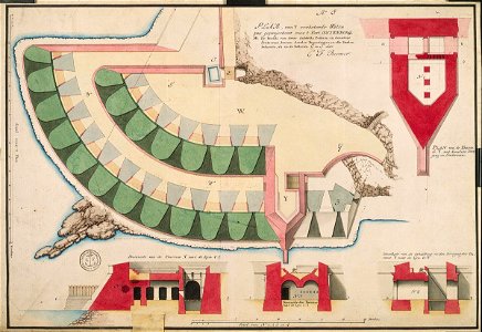
Waterway for Fort Oostenburg at Trinconomale, Carel Frederik Reimer, circa 1750
According to the leupe catalogue (na), the original title reads: plan van 't verbeterde waterpas, geprojecteert voor het fort oostenburg. Notes on reverse: [blue label [odg] nr: 23e geprojecteerd waterpas voor oostenburg. Date: circa 1750. Dimensions: height: 54 cm (21.2 in); width: 37 cm (14.5 in). Medium: coloured drawing on paper. Collection: Nationaal Archief. AMH-4525-NA Waterway for Fort Oostenburg at Trinconomale