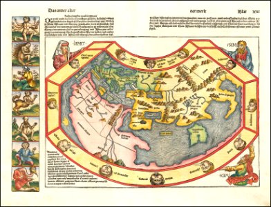
1493 map of the world by hartmann schedel, held up by biblical figures sem, japhet and cham. The map shows the known old world including europe, africa and asia (with tartaria, pathia, india and tabrobana). Antipodes on the left side. Latin and german texts explain what is displayed, in rough translation: the other age / of the world / page 13: common division of the world: the world is thus called a circumference as she is simply round a disc or ball. Also is the world divided into three parts, namely asia, africa and europe; but then not in similar fashion as asia reaches from mid-day over the sunrise to midnight while europe reaches from midnight to sundown and africa from sundown to mid-day. Now asia covers half the part of the habitable world, while africa and europe the other half. / between these parts run from the common see a big sea and divides these. Since the world is divided in two parts of sunrise/asia and sundown/africa and europe, it was divided by noah's sons after the deluge, and sem with his descendents owned asia, japhet europe and cham africa; as the [holy] script but also [john] chrysostom, isidore [of seville] and plinius report. Date: 1493.
Loading...