Atlas de Wit 1698-pl081-Maastricht-KB PPN 145205088 (Vroenhof)

Atlas de Wit 1698-pl081-Maastricht-KB PPN 145205088 (Vroenhof)

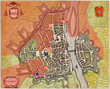
Old map of maastricht. Plate 081 from the stedenboek (book of towns) by frederick de wit from 1698. The map has been digitally edited by kleon3 to mark the territory of the county of vroenhof in and around maastricht (losely based on map 3 in: ubachs/evers, historische encyclopedie maastricht, zutphen, 2005). Vroenhof was a small county, a remnant of early medieval royal posessions, pertaining to the duchy of brabant from 1202 onwards. The blue dot marks the location of the hof van lenculen, the central administration building of the county.
Edit image
Published by:
Creazilla
Author: Frederik de WitSource: commons.wikimedia.org

Loading...

0 downloads
Loading...
map of maastricht by willem and johannes blaeu (1649)atlas de wit 1698vroenhof (maastricht)

MORE LIKE THIS

Creazilla logo
Over 10 million free graphic resources for content creators and designers.
© 2018 - 2025 Creazilla
Our resourcesAll imagesPhotosDigital illustrationsClipartIconsPNG ImagesEmojisSilhouettesTraditional Art3D ModelsVectorsFontsColor namesColor palettesGradientsAudioAnimationVideosTemplates
InformationAbout CreazillaTerms of useTech teamPrivacy policyLicence Information
FeedbackContact Us