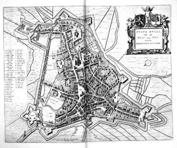
At the end of the eighty years war, joan blaeu (1596-1673) developed a plan to publish an atlas with all cities and fortresses in the northern and southern netherlands. He
published this atlas in two volumes in 1649. Although the city of 's-hertogenbosch was awarded to the republic at the peace of westphalen, this city plan was published in the second volume, which was dedicated to the
cities of the southern netherlands which at the time were ruled by spain. This error was corrected in later editions. Object Type: map. Date: 1649. Place of creation: Amsterdam. Dimensions: 42 x 53 cm. Medium: copper engraving print. Collection: British Library.
Loading...