Palatinat Electoral du Rhein. Map of the County Palatinate on the Rhyn., Daniel de Lafeuille, 1747 (undated)

Palatinat Electoral du Rhein. Map of the County Palatinate on the Rhyn., Daniel de Lafeuille, 1747 (undated)

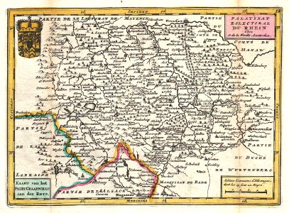
A stunning map of germany’s rhineland first drawn by daniel de la feuille in 1706. Depicts from alsace and lorraine eastward to württemberg ad northwards as far as mainz. Names heidelberg, manheim, frankfurt, mayence, darmstadt, manheim and landaw, as well as many other cities. This area, known as rhineland-palatinate, is known for its fine riesling wines. French title area in upper right quadrant, dutch title area in lower left. An armorial crest decorates the upper left quadrant. This is paul de la feuille’s 1747 reissue of his father daniel’s 1706 map. Prepared for issue as plate no. 13 in j. Ratelband’s 1747 geographisch-toneel. Date: 1747 (undated). Dimensions: height: 6.5 in (16.5 cm); width: 9 in (22.8 cm). 1747 La Feuille Map of Rhineland, Germany - Geographicus - Rhein-lafeuille-1747
Edit image
Published by:
Creazilla
Author: Daniel de Lafeuille (1640–1709)Source: commons.wikimedia.org

Loading...

0 downloads
Loading...
daniel de la feuilleold maps of rhineland-palatinate1747 mapsfrench-language mapsjohannes ratelbanddaniel de lafeuille

MORE LIKE THIS

Creazilla logo
Over 10 million free graphic resources for content creators and designers.
© 2018 - 2025 Creazilla
Our resourcesAll imagesPhotosDigital illustrationsClipartIconsPNG ImagesEmojisSilhouettesTraditional Art3D ModelsVectorsFontsColor namesColor palettesGradientsAudioAnimationVideosTemplates
InformationAbout CreazillaTerms of useTech teamPrivacy policyLicence Information
FeedbackContact Us