Zuyd America- - Southern America., Daniel de Lafeuille, 1747 (undated)

Zuyd America- - Southern America., Daniel de Lafeuille, 1747 (undated)

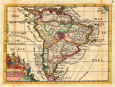
A stunning map of south america first drawn by daniel de la feuille in 1706. Continent is represented according to the 18th century political geography. Labels several important cities including cusco, quito, lima, san sebastian, and cartagena. Shows two large imaginary lakes in the interior. Title cartouche in the lower left hand quadrant features stylized images of native americans offering gifts to europeans while an enormous and eerily grinning serpent looks on. Title in both dutch and french. This is paul de la feuille’s 1747 reissue of his father daniel’s 1706 map. Prepared for issue as plate no. 7 in j. Ratelband’s 1747 geographisch-toneel. Date: 1747 (undated). Dimensions: height: 6 in (15.2 cm); width: 7.5 in (19 cm). 1747 La Feuille Map of South America - Geographicus - SouthAmerica-ratelband-1747
Edit image
Published by:
Creazilla
Author: Daniel de Lafeuille (1640–1709)Source: commons.wikimedia.org

Loading...

0 downloads
Loading...
daniel de la feuille1747 maps of south america18th-century maps of the spanish empirefrench-language maps of south americajohannes ratelbanddaniel de lafeuille

MORE LIKE THIS

Creazilla logo
Over 10 million free graphic resources for content creators and designers.
© 2018 - 2025 Creazilla
Our resourcesAll imagesPhotosDigital illustrationsClipartIconsPNG ImagesEmojisSilhouettesTraditional Art3D ModelsVectorsFontsColor namesColor palettesGradientsAudioAnimationVideosTemplates
InformationAbout CreazillaTerms of useTech teamPrivacy policyLicence Information
FeedbackContact Us