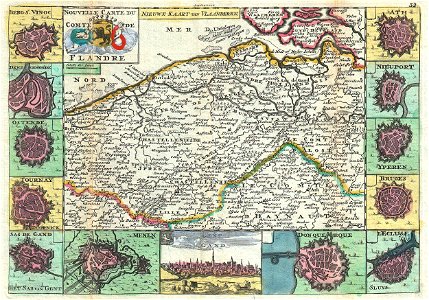
A stunning map of flanders, italy first drawn by daniel de la feuille in 1706. This region includes portions of what is today belgium and holland. Surrounded by thirteen views and plans of important villages and fortresses in this region. From top right in a clockwise fashion these include ath, nieuport, yperen, bruges, l’ecluse, donquerque (dunkirk), gent (gand), menen, sas de gand (he sas van gent), tournay (dooornick), ostende, dendermonde and berg st. Vinoc. Title in upper right quadrant in both french and dutch surrounding the flemish armorial shield. This is paul de la feuille’s 1747 reissue of his father daniel’s 1706 map. Prepared for issue as plate no. 38 in j. Ratelband’s 1747 geographisch-toneel. Date: 1747 (undated). Dimensions: height: 7 in (17.7 cm); width: 10.2 in (26 cm). 1747 La Feuille Map of Flanders ( Holland and Belgium) - Geographicus - Flandre-lafeuille-1747
Loading...