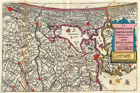
The Rhinlande Amstellande et Terres Circus uosines., Daniel de Lafeuille, 1747 (undated)
A stunning map of southern holland (the netherlands) and the vicinity of amsterdam first drawn by daniel de la feuille in 1706. Based upon an earlier map by balthazaro florentio a berkenrode who is credited in the title cartouche. Oriented to the southwest. Shows numerous sailing ships playing the haarlemmermeer and the zuiderzee. Covers from amsterdam southward as far as graven and nieupoort. This is paul de la feuille’s 1747 reissue of his father daniel’s 1706 map. Prepared for issue as plate no. 36 in j. Ratelband’s 1747 geographisch-toneel. Date: 1747 (undated). Dimensions: height: 7 in (17.7 cm); width: 10.2 in (26 cm). 1747 La Feuille Map of Amsterdam and Vicinity, the Netherlands - Geographicus - Amstellande-ratelband-1747