General Map of Spain. - The Kingdom of Spain with its Borders., Daniel de Lafeuille, 1747 (undated)

General Map of Spain. - The Kingdom of Spain with its Borders., Daniel de Lafeuille, 1747 (undated)

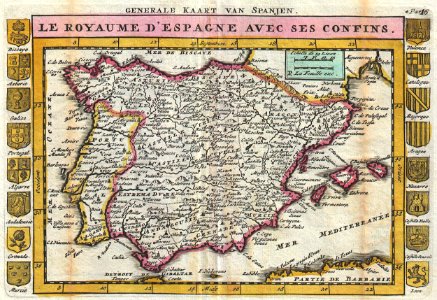
A stunning map of spain and portugal first drawn by daniel de la feuille in 1706. Depicts the entirety of iberia including the balearic islands, parts of france, and northern africa. Surrounded on either side by the armorial crests of 16 spanish regions. Title at top of map in french and, outside the margin, in dutch. This is paul de la feuille’s 1747 reissue of his father daniel’s 1706 map. Prepared for issue as plate no. 18 in j. Ratelband’s 1747 geographisch-toneel. Date: 1747 (undated). Dimensions: height: 7 in (17.7 cm); width: 10.2 in (26 cm). 1747 La Feuille Map of Spain and Portugal - Geographicus - Spain-ratelband-1747
Edit image
Published by:
Creazilla
Author: Daniel de Lafeuille (1640–1709)Source: commons.wikimedia.org

Loading...

0 downloads
Loading...
daniel de la feuille1740s maps of the iberian peninsula1747 maps of spain1747 maps of portugalfrench-language mapsjohannes ratelbanddaniel de lafeuille

MORE LIKE THIS

Creazilla logo
Over 10 million free graphic resources for content creators and designers.
© 2018 - 2025 Creazilla
Our resourcesAll imagesPhotosDigital illustrationsClipartIconsPNG ImagesEmojisSilhouettesTraditional Art3D ModelsVectorsFontsColor namesColor palettesGradientsAudioAnimationVideosTemplates
InformationAbout CreazillaTerms of useTech teamPrivacy policyLicence Information
FeedbackContact Us