Capitanata olim Mesapiae et Iapygiae pars., Willem Blaeu, 1630

Capitanata olim Mesapiae et Iapygiae pars., Willem Blaeu, 1630

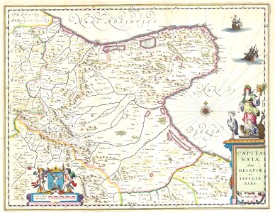
This is a magnificent c. 1630 map by willem blaeu represents the capitanata or puglia tableland in eastern italy. This area is often associated with the “spur of the boot”. This highly decorative map in a fine example of the blaeu style with multiple decoratie cartouches, sailing ships navigating the sea, and beautiful attention to detail. Principal cities depicted are foggia, cerignola, benivento, andria, and others. Date: 1630. Dimensions: height: 15 in (38.1 cm); width: 20 in (50.8 cm). 1630 Blaeu Map of Capitanata ( Foggia ), Italy - Geographicus - Capitanata-blaeu-1630
Edit image
Published by:
Creazilla
Author: Willem Blaeu (1571–1638)Source: commons.wikimedia.org

Loading...

0 downloads
Loading...
portolan charts by willem and johannes blaeulatin-language mapsold maps of capitanatawillem blaeu

MORE LIKE THIS

Creazilla logo
Over 10 million free graphic resources for content creators and designers.
© 2018 - 2025 Creazilla
Our resourcesAll imagesPhotosDigital illustrationsClipartIconsPNG ImagesEmojisSilhouettesTraditional Art3D ModelsVectorsFontsColor namesColor palettesGradientsAudioAnimationVideosTemplates
InformationAbout CreazillaTerms of useTech teamPrivacy policyLicence Information
FeedbackContact Us