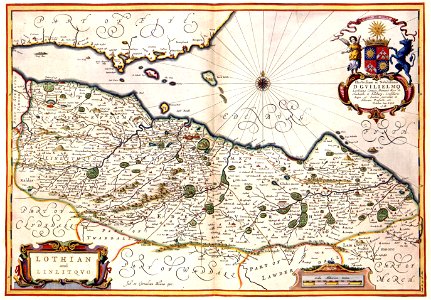
Joan blaeu (1598-1673) published his scottish atlas in 1654. This atlas contained maps that were not published before. The only exception was the map with the scottish counties lothian and linlithgow that had already been published in 1630. This version of the map was published between 1638 and 1642 by joan blaeu in cooperation with his brother cornelius blaeu (1610-1642). Object Type: map. Date: 1638-1642. Place of creation: Amsterdam. Dimensions: 38 x 54 cm. Medium: copper engraving print. Collection: Koninklijke Bibliotheek.
Loading...