Beizhili or Beijing, 1st Province of the Chinese Empire, Joan Blaeu

Beizhili or Beijing, 1st Province of the Chinese Empire, Joan Blaeu

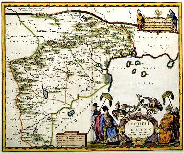
Appropriately, the sheet for hopeh that takes in peking is the most ornate of martinis fifteen provincial maps. Blaeus designer has provided a delightful title-piece, formed of two chinese elders seated in ornamental chairs, with their servants and a pair of flamboyant birds. Curiously, although peking had been named since the 15th century (after a spell as kublai khans camnalue), it is here spelled xuntien. Object Type: map. Date: 1690, from a 1655 original. Place of creation: Amsterdam. Dimensions: 40 x 48 cm. Medium: copper engraving print. Collection: Koninklijke Bibliotheek. Atlas Van der Hagen-KW1049B13 034-PECHELI SIVE PEKING IMPERII SINARVM PROVINCIA PRIMA
Edit image
Published by:
Creazilla
Author: Martino Martini (1614–1661) Author: Martino Martini Publisher: Joan Blaeu (1596–1673)Source: commons.wikimedia.org

Loading...

1 download
Loading...
atlas van der hagenatlas van der hagen (volume 4)novus atlas sinensisarmillary spheres in artcompasses in artgeographers in artmaps of the great wall of chinamaps with figuresanimals on mapsold maps of beijingold maps of tianjinold maps of hebeicopper engraving printkoninklijke bibliotheekjoan blaeu

MORE LIKE THIS

Creazilla logo
Over 10 million free graphic resources for content creators and designers.
© 2018 - 2025 Creazilla
Our resourcesAll imagesPhotosDigital illustrationsClipartIconsPNG ImagesEmojisSilhouettesTraditional Art3D ModelsVectorsFontsColor namesColor palettesGradientsAudioAnimationVideosTemplates
InformationAbout CreazillaTerms of useTech teamPrivacy policyLicence Information
FeedbackContact Us