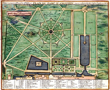
PLAN DU PARC DANGUIEN, Romeyn de Hooghe, circa 1685
The print shows a plan of the complex of pleasure gardens of enghien near brussels. The plan is part of a series of prints commissioned by nicolaes visscher ii (1649-1702) and engraved by romeyn de hooghe (1645-1708). The plan of the parc shows a division in three large sections with long and strait lanes between them, the so-called allées. Object Type: map. Date: circa 1685. Place of creation: Netherlands. Dimensions: 23,5 x 28 cm. Medium: copper engraving print. Collection: Koninklijke Bibliotheek. Atlas Van der Hagen-KW1049B11 075 3-PLAN DU PARC DANGUIEN